The Subaru-Asahi Star Camera perched atop Mauna Kea, Hawaii, captured a rare sighting of red sprites hovering above a distant thunderstorm on Feb. 5.
Strong storms could produce damaging wind gusts in The T&D Region from Friday afternoon into Friday night.
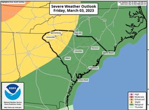
There is a marginal risk of severe storms across the region, according to a National Weather Service brief issued Thursday afternoon.
There’s a low tornado risk. The greatest chance of tornadoes is northwest of The T&D Region.
“The front has slowed a bit with showers and storms moving into the area from the west Friday evening into Friday night,” the NWS said. “A few strong storms may produce severe wind gusts leading to possible damage to trees and power lines.”
Breezy conditions with wind gusts of up to 40 mph are possible.
The strongest winds are expected between 1 p.m. Friday and 1 a.m. Saturday.
A lake wind advisory has been issued from noon Friday through 7 a.m. Saturday.
People are also reading…
“Boaters should use extra caution on lakes because the rough waves can cause small crafts to overturn,” the NWS said.
The breezy conditions could blow around loose outdoor objects, according to the NWS.
Following the passage of the cold front, sunshine will return on Saturday and continue through Tuesday. The next round of showers is forecast for Wednesday.
Temperatures will remain above normal with highs in the 70s and lows in the 40s and 50s.
#lee-rev-content { margin:0 -5px; } #lee-rev-content h3 { font-family: inherit!important; font-weight: 700!important; border-left: 8px solid var(–lee-blox-link-color); text-indent: 7px; font-size: 24px!important; line-height: 24px; } #lee-rev-content .rc-provider { font-family: inherit!important; } #lee-rev-content h4 { line-height: 24px!important; font-family: “serif-ds”,Times,”Times New Roman”,serif!important; margin-top: 10px!important; } @media (max-width: 991px) { #lee-rev-content h3 { font-size: 18px!important; line-height: 18px; } } #pu-email-form-daily-email-article { clear: both; background-color: #fff; color: #222; background-position: bottom; background-repeat: no-repeat; padding: 15px 0 20px; margin-bottom: 40px; border-top: 4px solid rgba(0,0,0,.8); border-bottom: 1px solid rgba(0,0,0,.2); display: none; } #pu-email-form-daily-email-article, #pu-email-form-daily-email-article p { font-family: -apple-system, BlinkMacSystemFont, “Segoe UI”, Helvetica, Arial, sans-serif, “Apple Color Emoji”, “Segoe UI Emoji”, “Segoe UI Symbol”; } #pu-email-form-daily-email-article h2 { font-size: 24px; margin: 15px 0 5px 0; font-family: “serif-ds”, Times, “Times New Roman”, serif; } #pu-email-form-daily-email-article .lead { margin-bottom: 5px; } #pu-email-form-daily-email-article .email-desc { font-size: 16px; line-height: 20px; margin-bottom: 5px; opacity: 0.7; } #pu-email-form-daily-email-article form { padding: 10px 30px 5px 30px; } #pu-email-form-daily-email-article .disclaimer { opacity: 0.5; margin-bottom: 0; line-height: 100%; } #pu-email-form-daily-email-article .disclaimer a { color: #222; text-decoration: underline; } #pu-email-form-daily-email-article .email-hammer { border-bottom: 3px solid #222; opacity: .5; display: inline-block; padding: 0 10px 5px 10px; margin-bottom: -5px; font-size: 16px; } @media (max-width: 991px) { #pu-email-form-daily-email-article form { padding: 10px 0 5px 0; } }