There are undoubtedly bigger dangers than being hit by lightning: The chance of being struck is less than one in a million. However, it’s better to be safe than sorry.
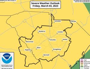
The T&D Region faces a slight chance of severe weather on Friday as a cold front approaches.
“A line of showers and storms moves into the area Friday. A few of these storms may become severe, producing damaging wind gusts or an isolated tornado,” the National Weather Service reported Wednesday.
The cold front will bring breezy conditions. Gusts of up to 40 mph are possible, according to the NWS.
The strongest gusts and greatest chance for severe weather is forecast to occur after noon Friday.
“Storms may produce severe wind gusts leading to possible damage to trees and power lines,” the NWS said. An “isolated tornado embedded in a line of storms may damage mobile homes, roofs, windows or vehicles.”
Breezy conditions may also blow around loose outdoor objects.
People are also reading…
Following the passage of the cold front on Friday, dry, high pressure will settle into the region on Saturday into early next week.
Weekend high temperatures are forecast to be in the low 70s, with lows in the 40s. It’s forecast to be sunny.
#lee-rev-content { margin:0 -5px; } #lee-rev-content h3 { font-family: inherit!important; font-weight: 700!important; border-left: 8px solid var(–lee-blox-link-color); text-indent: 7px; font-size: 24px!important; line-height: 24px; } #lee-rev-content .rc-provider { font-family: inherit!important; } #lee-rev-content h4 { line-height: 24px!important; font-family: “serif-ds”,Times,”Times New Roman”,serif!important; margin-top: 10px!important; } @media (max-width: 991px) { #lee-rev-content h3 { font-size: 18px!important; line-height: 18px; } } #pu-email-form-daily-email-article { clear: both; background-color: #fff; color: #222; background-position: bottom; background-repeat: no-repeat; padding: 15px 0 20px; margin-bottom: 40px; border-top: 4px solid rgba(0,0,0,.8); border-bottom: 1px solid rgba(0,0,0,.2); display: none; } #pu-email-form-daily-email-article, #pu-email-form-daily-email-article p { font-family: -apple-system, BlinkMacSystemFont, “Segoe UI”, Helvetica, Arial, sans-serif, “Apple Color Emoji”, “Segoe UI Emoji”, “Segoe UI Symbol”; } #pu-email-form-daily-email-article h2 { font-size: 24px; margin: 15px 0 5px 0; font-family: “serif-ds”, Times, “Times New Roman”, serif; } #pu-email-form-daily-email-article .lead { margin-bottom: 5px; } #pu-email-form-daily-email-article .email-desc { font-size: 16px; line-height: 20px; margin-bottom: 5px; opacity: 0.7; } #pu-email-form-daily-email-article form { padding: 10px 30px 5px 30px; } #pu-email-form-daily-email-article .disclaimer { opacity: 0.5; margin-bottom: 0; line-height: 100%; } #pu-email-form-daily-email-article .disclaimer a { color: #222; text-decoration: underline; } #pu-email-form-daily-email-article .email-hammer { border-bottom: 3px solid #222; opacity: .5; display: inline-block; padding: 0 10px 5px 10px; margin-bottom: -5px; font-size: 16px; } @media (max-width: 991px) { #pu-email-form-daily-email-article form { padding: 10px 0 5px 0; } }