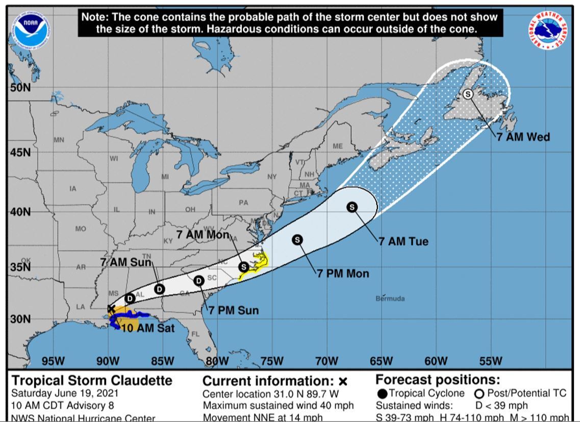
Claudette to bring rain to region

.tnt-restrict-img-96af294d-0549-577f-aa07-18ccd581a0ab { max-width: 1137px; }
Tropical Storm Claudette
Tropical Storm Claudette is forecast to cause a wet Sunday in The T&D Region, according to the National Weather Service.
While the storm will weaken as it crosses the central Gulf states, there is the potential for heavy rainfall and flash flooding through Sunday afternoon. The wind threat is minimal.
There’s an 80 percent chance of rain on Sunday, with forecasts calling for up to three-quarters of an inch. Winds could reach 15 mph, with gusts up to 25 mph.
The high is forecast to be 83.
There’s also an 80 percent chance of rain on Sunday night, with forecasts calling for up to three-quarters of an inch of rain.

Thunderstorms are also a possibility Sunday and Sunday night. The National Weather Service says there’s low potential for isolated tornadoes early Sunday into Sunday afternoon.
Monday will be partly sunny with a possibility of showers and thunderstorms. The high will be near 89.
#pu-email-form-daily-email { clear: both; background-color: #fff; color: #222; background-position: bottom; background-repeat: no-repeat; padding: 15px 20px; margin-bottom: 40px; box-shadow: 0px 2px 0px 0px rgba(0,0,0,.05); border-top: 4px solid rgba(0,0,0,.8); border-bottom: 1px solid rgba(0,0,0,.2); display: none; } #pu-email-form-daily-email, #pu-email-form-daily-email p { font-family: -apple-system, BlinkMacSystemFont, “Segoe UI”, Helvetica, Arial, sans-serif, “Apple Color Emoji”, “Segoe UI Emoji”, “Segoe UI Symbol”; } #pu-email-form-daily-email h1 { font-size: 24px; margin: 15px 0 5px 0; font-family: “serif-ds”, Times, “Times New Roman”, serif; } #pu-email-form-daily-email .lead { margin-bottom: 5px; } #pu-email-form-daily-email .email-desc { font-size: 16px; line-height: 20px; margin-bottom: 5px; opacity: 0.7; } #pu-email-form-daily-email form { padding: 10px 30px 5px 30px; } #pu-email-form-daily-email .disclaimer { opacity: 0.5; margin-bottom: 0; line-height: 100%; } #pu-email-form-daily-email .disclaimer a { color: #222; text-decoration: underline; } #pu-email-form-daily-email .email-hammer { border-bottom: 3px solid #222; opacity: .5; display: inline-block; padding: 0 10px 5px 10px; margin-bottom: -5px; font-size: 16px; }
Leave a Reply