The National Weather Service has now confirmed a tornado struck Bamberg and Orangeburg counties on Tuesday. It previously confirmed one in Calhoun County.
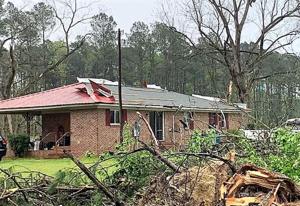
A total of 46 homes in Bamberg and Orangeburg counties were either destroyed or damaged during the severe weather.
NWS Meteorologist Dan Miller said preliminary assessments show the area’s damage is “consistent with at least an EF3 tornado.”
An EF3 tornado has winds between 136 mph and 165 mph.
Miller said it appears the tornado began in Allendale County and then moved across Bamberg County and into Orangeburg County, destroying mobile homes and ripping the bark off of trees along its path.
No deaths or injuries were reported as a result of the tornado.
Orangeburg County Emergency Services reported a total of 15 homes were damaged by the storms, with one home destroyed and two homes with major damage. The three homes that were destroyed or suffered major damage cannot be lived in.
People are also reading…
The heaviest hit area was about five miles north of Branchville on Seacrest Lane and Greywood Drive.
Orangeburg County Emergency Services Director Billy Staley said a funnel cloud was also possibly sighted in the Elloree area shortly before 10 p.m. Wednesday.
The NWS reported there were power lines down about one mile west of the Elloree.
Staley said he was going to search for any possible indications that a tornado touched down in the area.
In Bamberg County, a total of 31 homes were damaged. Of those, 23 are completely destroyed and uninhabitable, Bamberg County Public Information Officer Sh’Kur Francis said.
The Hunters Chapel and Colston communities sustained the most significant damage in the storm.
The American Red Cross was busy assisting about 19 individuals in Bamberg County affected by Tuesday’s storms. They included individuals on Carver Road, Macedonia Church Road, Pocketville Road and in Ehrhardt.
The agency is providing financial assistance for immediate needs such as food, clothing and shelter, along with referrals to resources.
Francis said Bamberg County dirt roads are passable but that motorists are encouraged to exercise caution on the roads due to their poor condition.
Tornado survey teams with the National Weather Service have confirmed at least five tornados ranging from ESF-1 to EF-3 in South Carolina, according to a S.C. Emergency Management Division press release.
The SCEMD also reported:
• Allendale: Four homes destroyed, 11 homes damaged, 15 homes impacted in total. Local emergency management officials reported three non-life-threatening injuries.
• Clarendon: Three homes destroyed.
• Horry: Five homes damaged, none destroyed.
With more detailed assessments ongoing, these estimates will be revised in the coming days.
A survey of an EF1 tornado in Lexington and Calhoun counties, which was reported Wednesday, revealed the tornado started just north of Gaston, traveled across Interstate 26 and dissipated prior to reaching the Congaree River.
The tornado was on the ground from 6:20 p.m. to 6:29 p.m. April 5.
The peak winds were 105 miles per hour. The maximum width of the tornado was 40 yards, according to the NWS.
The tornado traveled 5.89 miles, starting about one mile north of Gaston. It entered Calhoun County around Calhoun Hill Road, traveling parallel to Savany Hunt Creek Road before crossing Interstate 26 and traveling over U.S. 176 before lifting up or dissipating around Plantation Estates Lane.
Calhoun County emergency officials say about 2.6 miles of the tornado’s path was in Calhoun County.
No damage to homes or structures was reported in Calhoun County as a result of Tuesday’s storms. The storms primarily downed trees and power lines in the county.
Heavy rainfall over the past couple of days has caused many area rivers to rise.
The North Fork of the Edisto River in Orangeburg is forecast to crest at 8.8 feet Friday evening. The flood stage is 8 feet.
At this stage, there is some minor flooding along the boardwalk at Edisto Memorial Gardens.
Downstream from the Highway 301 bridge, some roads off Chiquita Street near the river begin to flood.
The Congaree River at Carolina Eastman is forecast to crest around 121.7 feet. Flood stage for the river is 115 feet.
At this level, extensive flooding occurs in the Congaree National Park. Some area farmland is flooded. Minor flooding also occurs at the Carolina Eastman facility.
#pu-email-form-daily-email-article { clear: both; background-color: #fff; color: #222; background-position: bottom; background-repeat: no-repeat; padding: 15px 20px; margin-bottom: 40px; border-top: 4px solid rgba(0,0,0,.8); border-bottom: 1px solid rgba(0,0,0,.2); display: none; } #pu-email-form-daily-email-article, #pu-email-form-daily-email-article p { font-family: -apple-system, BlinkMacSystemFont, “Segoe UI”, Helvetica, Arial, sans-serif, “Apple Color Emoji”, “Segoe UI Emoji”, “Segoe UI Symbol”; } #pu-email-form-daily-email-article h1 { font-size: 24px; margin: 15px 0 5px 0; font-family: “serif-ds”, Times, “Times New Roman”, serif; } #pu-email-form-daily-email-article .lead { margin-bottom: 5px; } #pu-email-form-daily-email-article .email-desc { font-size: 16px; line-height: 20px; margin-bottom: 5px; opacity: 0.7; } #pu-email-form-daily-email-article form { padding: 10px 30px 5px 30px; } #pu-email-form-daily-email-article .disclaimer { opacity: 0.5; margin-bottom: 0; line-height: 100%; } #pu-email-form-daily-email-article .disclaimer a { color: #222; text-decoration: underline; } #pu-email-form-daily-email-article .email-hammer { border-bottom: 3px solid #222; opacity: .5; display: inline-block; padding: 0 10px 5px 10px; margin-bottom: -5px; font-size: 16px; } @media (max-width: 991px) { #pu-email-form-daily-email-article form { padding: 10px 0 5px 0; } }
